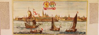
Arnhem 1649
Joan Blaeu
€ 750
Inter-Antiquariaat Mefferdt & De Jonge
- Über Kunstwerk
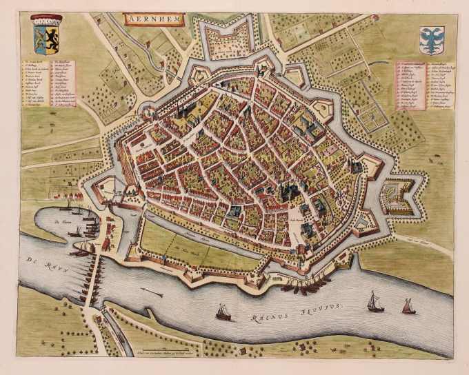
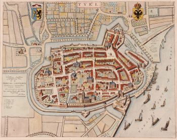
PLATTEGROND OF 17E-EEU ARNHEM "Aernhem", copper engraving by Joan Blaeu, as part of his "Toonneel der Steden", published in 1649 in Amsterdam. Later hand-coloured. Verso: Latin text. Sizes: 41 x 52,5 cm. The map was not drawn by Joan Blaeu, but by the cartographer Nicolaes van Geelkercken in 1639. Van Geelkercken received the commission for this from the Arnhem city council in 1638. The map thus reflects the situation around 1639. Van Geelkercken's design is not only found in this edition by Blaeu, but the printers Johannes Janssonius and Frederik de Wit also published variations on the map. Blaeu describes the city as follows: Arnhem is the capital of the Veluwe and seat of the highest court of the Duchy of Gelre. The city is "mighty, glorious, strong and rich in citizens". The Rhine flows along the city wall and the air is good because of the surrounding forests. In the surrounding area, the citizens have pleasant courtyards and gardens. On the side of the Veluwe, in the direction of Maastricht, there is a hill outside the city, "from the welcke sich a lustige aenschouwing over de naeste landen van de Betuwe vert vert vert". North of the town are hills and valleys planted with woods and heathland, where various kinds of wild animals are hunted. There is also the Wildhaen, once the hunting ground of the dukes, now "very useful for a walk for the citizens". To the south of the town, on the other side of the Rhine, are the beautiful fields of the Betuwe, where many oats, barley, peas, beans and other grain crops grow. Against "the violence from outside" the city has five "as strong as a castle" gates (four are made of stone). Of these, St. John's Gate was built in 1537 by Charles of Gelre, who feared the arrival of Charles V. Blaeu writes about the nature of the citizens that they are "courteous and lovers of science, and many live there from noble families". They are also heroic. Think of the city of Neuss that was helped by the citizens of Arnhemm during the siege by Charles the Bold. They also provided help during the terrible fire of Harderwijk in 1503. The city has a chapter of canons [in the St. Walburgis church], a Franciscan monastery [Broeren church on the map] and an Agnietenklooster [which passed into the hands of the St. Catharina Gasthuis in 1636]. The Commanderij van Sint-Jan is home to the Hospitaller knights, who used to collect a toll at the Janspoort on goods imported from the Veluwe, until this privilege was bought off by the bishop of Utrecht. In the Grote Kerk, with its beautiful tower, Duke Charles of Gelre is buried "in the inner court, of carved marble". See here for a nice animation of 17th century Arnhem. Price: Euro 750,-
- Über Künstler
Joan Blaeu (1596-1673), wurde am 23. September 1596 in Alkmaar geboren.
Er war ein niederländischer Kartograph, der in Alkmaar geboren wurde. Er trat in die Fußstapfen seines Vaters, des Kartografen Willem Blaeu.
1620 wurde er promovierter Jurist, trat aber in das Werk seines Vaters ein. 1635 veröffentlichten sie den Atlas Novus (vollständiger Titel: Theatrum orbis terrarum, sive, Atlas novus) in zwei Bänden. Joan und sein Bruder Cornelius übernahmen das Atelier nach dem Tod ihres Vaters im Jahr 1638. Joan wurde der offizielle Kartograf der Niederländischen Ostindien-Kompanie.
Blaeus Weltkarte Nova et Accuratissima Terrarum Orbis Tabula, die die Entdeckungen von Abel Tasman enthält, wurde 1648 veröffentlicht. Diese Karte war insofern revolutionär, als sie „das Sonnensystem gemäß den heliozentrischen Theorien von Nicolaus Copernicus darstellt, die zeigen, dass sich die Erde um sie dreht die Sonne .... Obwohl Kopernikus' bahnbrechendes Buch "Über die Revolutionen der Sphären" erstmals 1543 gedruckt wurde, war Blaeu etwas mehr als ein Jahrhundert zuvor der erste Kartograph, der diese revolutionäre heliozentrische Theorie in eine Weltkarte einfließen ließ."
Blaeus Karte wurde für die Weltkarte kopiert, die 1655 in das Pflaster des Groote Burger-Zaal des neuen Amsterdamer Rathauses eingelassen wurde, das vom niederländischen Architekten Jacob van Campen (heute Amsterdamer Königspalast) entworfen wurde.
Blaeus Hollandia Nova wurde auch in seinem 1659 erschienenen Archipelagus Orientalis sive Asiaticus im Kurfürsten-Atlas (Atlas des Großen Kurfürsten) abgebildet. und von Melchisédech Thévenot zur Erstellung seiner Karte Hollandia Nova – Terre Australe (1664) verwendet.
Als „Jean Blaeu“ veröffentlichte er auch den 12-bändigen „Le Grand Atlas, ou Cosmographie blaviane, en laquelle est Exactement descritte la terre, la mer, et le ciel“. Eine Ausgabe ist auf 1663 datiert. Das war Folio (540 x 340 mm) und enthielt 593 gestochene Karten und Tafeln. Im März 2015 wurde eine Kopie für 750.000 £ verkauft.
Um 1649 veröffentlichte Joan Blaeu eine Sammlung niederländischer Stadtpläne mit dem Titel Toonneel der Steeden (Ansichten von Städten). 1651 wurde er in den Amsterdamer Rat gewählt. 1654 veröffentlichte Joan den ersten schottischen Atlas, der von Timothy Pont entworfen wurde. 1662 gab er den Atlas Novus, auch bekannt als Atlas Maior, in 11 Bänden und einem für Ozeane neu heraus.
Als nächstes Projekt war eine Kosmologie geplant, doch 1672 zerstörte ein Brand das Atelier vollständig.
Joan Blaeu starb im folgenden Jahr, 1673, in Amsterdam. Er wurde in der Westerkerk in Amsterdam begraben.
Sind Sie daran interessiert, dieses Kunstwerk zu kaufen?
Artwork details
Related artworks
- 1 - 4 / 12
- 1 - 4 / 24
- 1 - 4 / 12

