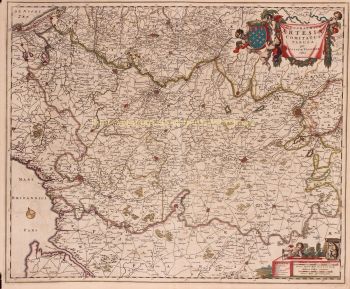
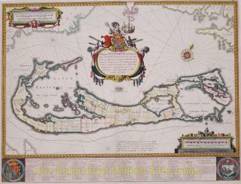
Achterhoek (Grafschaft Zutphen) 1641
Johannes Janssonius
€ 295
Inter-Antiquariaat Mefferdt & De Jonge
- Über Kunstwerk
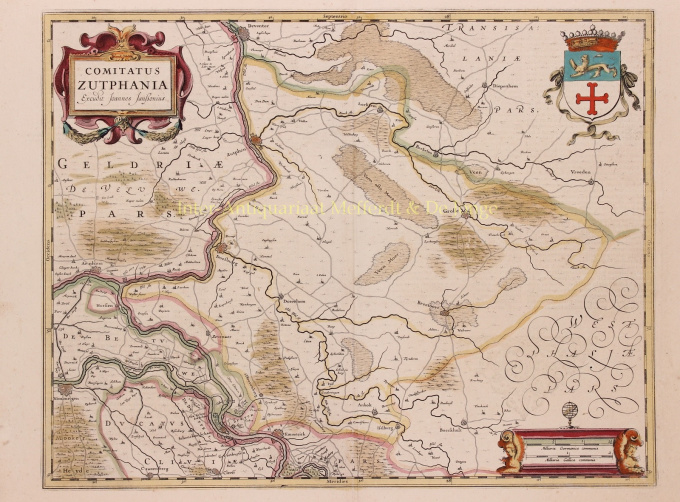
THE QUARTER OF ZUTPHEN "Comitatus Zutphania", copper engraving published by Johannes Janssonius in 1641 as part of his "Nouveau Theatre du Monde ou Nouvel Atlas". Coloured by hand at the time. Measures 46.5 x 56.4 cm. In the years 1557 to 1559 the area was mapped by Christiaan sGrooten. sGrooten's map of Gelderland was also the model for Janssonius' map of the County of Zutphen. We see the Kleef area near Huissen and Zevenaar clearly delimited. Isselburg falls within the border of the County. There are no siege works drawn around Groenlo. The area of the manor of Borculo fell under the Earldom after 1615, but is shown here as part of the Bishopric of Münster. For the city of Zutphen, the Eighty Years' War brought difficult times. In 1572, Zutphen was captured by William of Orange's brother-in-law. The Spaniards were driven out, but half a year later they took the city back and executed hundreds of inhabitants. In 1577, the Spaniards left the city, but the Catholic city council remained in place. In the summer of 1579, the Protestants seized power and deposed the Roman Catholic administrators. In 1583, Zutphen was again in the hands of the Spaniards but after that, the city was besieged two more times by the Staatsen. In 1591, Prince Maurits conquered Zutphen until, in 1629, a German-Spanish army once again invaded the Veluwe and went on a killing spree. Top right, the city arms of Zutphen are depicted, with the Count's Crown on top. Bottom right the scale of the map is flanked by winged angels with claws, on top is an armillary as a symbol of wisdom and knowledge (of the mapmaker). Price: Euro 295,-
- Über Künstler
Janssonius wurde in Arnheim als Sohn des dortigen Druckers und Verlegers Jan Jansz geboren. In jungen Jahren zog er nach Amsterdam, dem damaligen Zentrum des Druck- und Kartenhandels. 1612 heiratete er Elisabeth Hondius, Tochter des Jodocus Hondius. Elisabeth starb 1627 und Janssonius heiratete 1629 erneut mit Elisabeth Carlier. Er arbeitete für seinen Schwiegervater und führte nach dessen Tod zusammen mit Henricus Hondius (Sohn von) die Verlagsgeschäfte weiter. Diese wurde zu einer der größten ihrer Zeit ausgebaut. Niederlassungen gab es unter anderem in Berlin, Frankfurt, Genf, Lyon und Stockholm.
Unter der Leitung von Janssonius wurde der Mercator-Hondius-Atlas erweitert und als Atlas Novus veröffentlicht. Aus dieser zunächst einbändigen Ausgabe wurde bald ein mehrbändiger Atlas, auf Wunsch ergänzt durch Seekarten und/oder Himmelskarten. Es gab Veröffentlichungen in Niederländisch, Französisch, Spanisch und Latein. Ebenso wie seine Zeitgenossen bediente sich Janssonius auch vorhandener Kupferplatten, unter anderem aus den Stadtbüchern von Braun & Hogenberg und der Description de touts les Pays Bas (Beschreibung der ganzen Niederlande) von Lodovico Guicciardini – (Edition Cornelis Claesz.) aus 1609 Obwohl Janssonius oft beschuldigt wurde, Willem Blaeus Werke kopiert zu haben, sei darauf hingewiesen, dass auch Karten von Janssonius schon früher auf dem Markt erschienen.
Nach dem Tod von Janssonius wurde die Firma von seinem Schwiegersohn, Johannes (Jan) van Waesbergen, der mit seiner Tochter Elisabeth Janssonius (1615-1681) verheiratet war, weitergeführt. Viele Kupferplatten der Stadtbücher wurden (manchmal leicht modifiziert) von Frederik de Wit verwendet. Das Gebäude am Dam-Platz wurde an Gerard Valck verpachtet; 1694 kaufte er auch eine Reihe von Druckplatten.
Sind Sie daran interessiert, dieses Kunstwerk zu kaufen?
Artwork details
Related artworks
- 1 - 4 / 4
- 1 - 4 / 24
- 1 - 4 / 12

