Antique map of South East Asia - Johannes Janssonius by Johannes Janssonius
Scroll to zoom, click for slideshow

Antique map of South East Asia - Johannes Janssonius 1630

Johannes Janssonius

Papier
39 ⨯ 50 cm
€ 1.850

Inter-Antiquariaat Mefferdt & De Jonge

  • Über Kunstwerk
    A LANDMARK EARLY MAP OF SOUTHEAST ASIA, THE PHILIPPINES, AND AUSTRALIA “Indiae Orientalis Nova Descriptio.“ Copper engraving published by Johannes Janssonius (in English also known as Jan Jansson) in 1630. With original hand colouring. Size (plate mark): 39 x 50,7 cm. This edition of Johannes Janssonius’ map—first appearing in his “Appendix” in 1630—is celebrated for its excellent regional detail and its historical significance. It is notably the only Dutch printed map to record the 1606 discoveries of captain Willem Janszoon aboard the Duyfken, an expedition that led to the first recorded European landing on Australian soil, specifically on the west coast of Cape York Peninsula. In the early 17th century, the Dutch East India Company (VOC) was eager to expand its trade monopoly in the East Indies. In 1605, at the initiative of the VOC, Jan Willemsz Verschoor organized an expedition "to discover the great land of New Guinea and other eastern and southern lands." Willem Janszoon (1570-1636) was selected for this pioneering expedition, setting sail from Bantam (Indonesia) in late 1605. According to John Saris, an agent for the British East India Company, the Duyfken departed on November 28, 1605. In early 1606, after navigating New Guinea’s south coast, Jansz sailed south across Torres Strait—mistaking it for a shallow bay—and continued along what he presumed was the continuation of New Guinea’s coastline. In truth, he was venturing into the waters off the Australian coast. Unbeknownst to him, this voyage marked the first recorded European encounter with Australian soil. In addition, the map also presents the Philippines in detail for the first time. Janssonius drew upon the work of VOC cartographer Hessel Gerritsz, utilizing information that the VOC had strictly controlled in the early 17th century for competitive reasons. Janssonius’ map is significant not only for its depiction of the discoveries in New Guinea, referred to as “Duyfkens Eylant,” but also as the sole printed cartographic record of part of the Duyfken’s route until later maps emerged. While the map uses a scale of miles to cover the area of the Australian discoveries—thus offering less detail on Jansz’s Australian findings—it remains an invaluable document in the history of European exploration in the region. Price: Euro 1.850,- (incl. frame)
  • Über Künstler

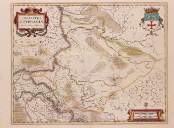
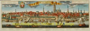
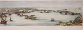
    Janssonius wurde in Arnheim als Sohn des dortigen Druckers und Verlegers Jan Jansz geboren. In jungen Jahren zog er nach Amsterdam, dem damaligen Zentrum des Druck- und Kartenhandels. 1612 heiratete er Elisabeth Hondius, Tochter des Jodocus Hondius. Elisabeth starb 1627 und Janssonius heiratete 1629 erneut mit Elisabeth Carlier. Er arbeitete für seinen Schwiegervater und führte nach dessen Tod zusammen mit Henricus Hondius (Sohn von) die Verlagsgeschäfte weiter. Diese wurde zu einer der größten ihrer Zeit ausgebaut. Niederlassungen gab es unter anderem in Berlin, Frankfurt, Genf, Lyon und Stockholm.

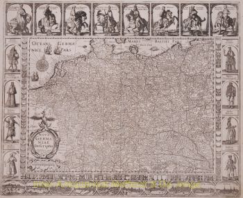
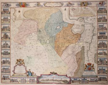
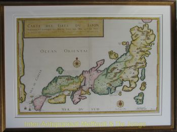
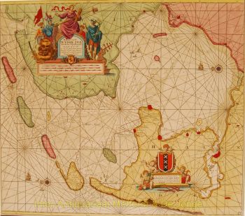
    Unter der Leitung von Janssonius wurde der Mercator-Hondius-Atlas erweitert und als Atlas Novus veröffentlicht. Aus dieser zunächst einbändigen Ausgabe wurde bald ein mehrbändiger Atlas, auf Wunsch ergänzt durch Seekarten und/oder Himmelskarten. Es gab Veröffentlichungen in Niederländisch, Französisch, Spanisch und Latein. Ebenso wie seine Zeitgenossen bediente sich Janssonius auch vorhandener Kupferplatten, unter anderem aus den Stadtbüchern von Braun & Hogenberg und der Description de touts les Pays Bas (Beschreibung der ganzen Niederlande) von Lodovico Guicciardini – (Edition Cornelis Claesz.) aus 1609 Obwohl Janssonius oft beschuldigt wurde, Willem Blaeus Werke kopiert zu haben, sei darauf hingewiesen, dass auch Karten von Janssonius schon früher auf dem Markt erschienen.

    Nach dem Tod von Janssonius wurde die Firma von seinem Schwiegersohn, Johannes (Jan) van Waesbergen, der mit seiner Tochter Elisabeth Janssonius (1615-1681) verheiratet war, weitergeführt. Viele Kupferplatten der Stadtbücher wurden (manchmal leicht modifiziert) von Frederik de Wit verwendet. Das Gebäude am Dam-Platz wurde an Gerard Valck verpachtet; 1694 kaufte er auch eine Reihe von Druckplatten.

Sind Sie daran interessiert, dieses Kunstwerk zu kaufen?